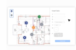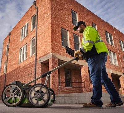
Advancements in utility location devices using ground penetrating radar continue, as Subsite launches its GeoRanger XR Series.
The GPR-equipped carts in the series can detect shallow and deep utilities in a single pass, including ones without tracer wires, the company says.
The new series consists of the GeoRanger XR and the more advanced XR2 model.
The XR is equipped with dual-frequency antennas of 750 MHz, which can detect objects down to 10 feet, and 350 MHz for depths down to 20 feet.
The XR2 adds in GPS mapping with real-time kinematic (RTK) correction technology designed to increase accuracy up to 2 centimeters. It also comes preloaded with software for streamlined data processing and visualization to generate detailed reports, the company says.
 Subsite
- WiFi-Enabled, Cableless Design – for simplified setup.
- Magnetic Field Sensor – sweeps for power and differentiates energized lines from other objects for more reliable locating.
- Adjustable Antenna – to prevent damage in different terrain or to meet other jobsite demands.
- Adjustable Handle – two positions to set the cart’s handle height.
- All-Terrain Wheels – help when in high grass and other difficult terrain.
- Surveyor Mobile App – allows you to scan your project via mobile device. It is compatible with both iOS and Android systems.
The XR2 has all the above features as well as these:
- Integrated GPS – for increased location accuracy.
- RTK Accuracy – Built with real-time kinematic technology designed to enhance GPS accuracy. (This service may require third-party subscription.)
- ESS Cloud – for access to equipment registration, instructional videos, software updates, RTK and cellular subscription information.
- ESS Software – “Compatible with Earth Science System’s Essential Underground software that allows you to match your software view to your needs, easily switching between project view, surfaces view, section view, depth view and 2D/3D view.”
- Surveyor Pro Software – Compatible with GPR data acquisition software to simplify plan management and reporting.
- PC Tablet – Comes with rugged DT Research PC for in-field processing and simplified reporting via acquisition software.
The GeoRanger cart is designed for durability and is made from composite of plastic and fiberglass, Subsite says. The company adds that the GeoRangers require minimal setup and training and come ready to work out of the box.
The GeoRangers are available at Ditch Witch dealers. Subsite was formed in 1988 to develop guidance systems for Ditch Witch’s horizontal directional drills.