 (Photo: Caltrans)
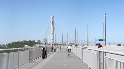
A bike and pedestrian path on the East span of the San Francisco-Oakland Bay Bridge opened to the public Tuesday, just one day after the span opened vehicle traffic, according to a report from San Francisco’s ABC7.
The 15.5-foot path features two bicycle lanes and one pedestrian lane, with an uphill trail from Oakland toward Verba Buena Island. The bridge’s path is currently a 4-mile round-trip between Oakland and the island, but the incomplete trail ends at the bridge’s suspension tower. Once completed, the path will take cyclists and pedestrians to Verba Buena Island.
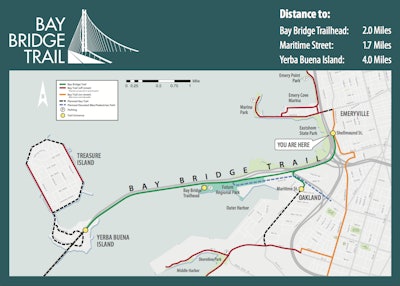 A map details a plan for the Bay Bridge bike and pedestrian path, which will eventually lead to Verba Buena Island. (Photo: Caltrans)
There are two entrances to the bike and pedestrian path: one at Shellmound Street in Emeryville and another at the corner of Maritime Street and Burma Road in West Oakland. The trail from either entrance to the span is 2 miles long, plus an additional 2-mile trip on the bridge.
Two-hour parking is available from 7 a.m. to 8 p.m. daily on the north side of Burma Road.
The California Department of Transportation (Caltrans) has outlined the following safety points for the path on the Bay Bridge website:
-
15-mph advisory speed limit
-
Bicycle-mounted California Highway Patrol (CHP) officers will patrol the path
-
Skateboards and skates are not permitted
-
Cyclists must yield to pedestrians
The path is open from sunrise to sunset until construction is completed; then the path will be open all day, every day.
For more information about the Bay Bridge bicycle and pedestrian path, click here.

