Canada-based robotics company Optimotive says its new Iris MK2 wheeled autonomous robot can collect construction jobsite data “faster, cheaper and more effectively” than traditional methods.
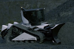
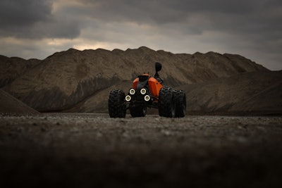
The rugged robot looks like a scaled-down ATV with no operator seat – and for good reason, it’s built to handle muddy, dusty and unpredictable terrain. It can be outfitted with a variety of sensor payloads for automated 3D scanning, 360-degree photo capture and remote inspections on complex jobsites in extreme conditions.
If the concept sounds familiar, you may remember our coverage of ClearPath Robotics’ Warthog robot that was undergoing field testing at last year's Trimble Dimensions user conference.
Iris MK2 can support topographical surveys pre-construction, 3D scanning during the build phase and inspection of solar panels and belt systems for preventative maintenance, capturing high-quality, consistent scans from the same height and position every time.
Optimotive says the cost-effective Iris MK2 is designed to deliver “precise, repeatable, and consistent data capture,” while reducing the cost and inefficiency of sending engineers into the field. For this reason, Optimotive says large contractors with BIM teams are ideal customers.
“We designed IRIS from the ground up for the real world, not the lab. IRIS MK2 is rugged, flexible, and powerful enough to work in environments where others fail,” said Scott Fairley, CEO and founder of Optimotive. “It’s not just a robot, it’s a force multiplier for digital transformation on industrial job sites.”
Key features include:
- Modular Payload System: Customizable to carry LiDAR, thermal imaging, 360-degree cameras, and more.
- Autonomous Navigation: Optimized for complex outdoor environments.
- Robot-as-a-Service Model: Flexible leasing with no monthly minimum. Setup from $10,000, with recurring costs starting at $3,500 per month.
- Fully Integrated Base Station ‘The Box’: The rugged and secure, all-in-one robotic base station provides charging, data upload, Starlink connectivity and solar power, enabling near-total autonomy.
- PointPerfect RTK GNSS by u-blox: Enables 1–3 centimeter accuracy using L-band and IP correction data, ideal for remote and urban deployment without needing a base station.
“We’re investing heavily into u-blox technology because it grows with us. From RTK precision to scalable deployment, PointPerfect gives us flexible, real-time accuracy, whether we’re in the middle of a city or the middle of nowhere,” said Fairley.