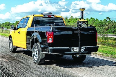
Topcon has launched a vehicle-mounted system for mapping road surfaces for road construction work that allows scanning at highway speeds.
The information collected can be used to enhance work for pavers or milling machines for machine control using GNSS with sonic tracer sensor guidance, the company says.
Because the SmoothRide system can scan at high speeds, crews no longer need typical road surveying equipment including crash trucks and escort vehicles, nor are lane closures required, says Topcon’s Murray Lodge, senior vice president and general manager, Construction Business Unit.
“With the new RD-M1 scanning unit, the system maps the existing surface elevations—with many more points captured versus what can be expected with traditional tools—providing more accurate data needed to confidently estimate materials, as well as form the basis of the final design surface,” Lodge explains.
Data collected by the system can be processed using the Mobile Master Office to recreate an existing roadway, following by a high-resolution model of the finished mat processed by MAGNET Office with Resurfacing. This model, Topcon says, helps in creating the mat design to meet thickness, cross slope and smoothness requirements.
“That information is taken to a paver or milling machine, allowing variable depth performance,” Lodge says. “The result is a much smoother road and faster completion times.”


