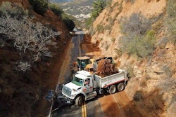
A large portion of State Route 35 near Castle Rock State Park in Santa Clara County, in the San Francisco Bay Area, collapsed due to a major wash out February 10, 2017. California DOT photo.
Caltrans has released its first Climate Change Vulnerability Assessment, which is an effort by the department to understand how and where the future effects of climate change may impact the state highway system and its users.
Spotlighting the grim need for such assessments are the lethal mudslides on Tuesday, January 9, in Southern California. At least 17 are dead, with more people missing and dozens injured in Santa Barbara County.
Thousands were forced to flee as the rain-driven mudslides, along with flooding and rivers of flowing debris, destroyed homes and cars, uprooted trees, and covered roadways. Authorities are assessing the damage, with the wealthy community of Montecito hit especially hard only weeks after residents fled record-setting wildfires.
According to Caltrans, extreme environmental events and associated costs are expected to become more pronounced and more frequent as a result of climate change.
“Climate change poses an immediate and growing threat to California, and Caltrans is being proactive in determining what this means for the state’s transportation system,” Malcolm Dougherty, Caltrans director, had commented upon release of the assessment just two weeks before the mudslides in Santa Barbara County.
That climate change vulnerability assessment, released December 27, found that the past storm season in California caused severe flooding, landslides and coastal erosion totaling more than $1.2 billion in highway damages statewide.
Nearly $390 million of those damages occurred in the San Francisco Bay Area region, which is in Caltrans District 4, north of Santa Barbara County.
Studying how climate change impacts state highways
“This study and those that will follow intend to provide data to support the discussion about how climate change impacts the way we plan, design, build, operate and maintain the state highway system,” says Dougherty.
This assessment evaluated the vulnerability of the San Francisco Bay Area region’s (Caltrans District 4’s) infrastructure, and is the first of twelve such studies that will eventually cover each Caltrans region of the state, the agency says.


The assessment identifies specific locations along the state highway system in the Bay Area that may be affected by rising sea levels and larger storm surge, more frequent wildfires, changing precipitation patterns and increasing temperatures associated with climate change, especially in the future.
These state highways are critically important not only for the San Francisco Bay Area, but also for intra-state travel and commerce, according to the department.
By identifying the possible risks and implications of climate change, the reports seek to guide future planning processes and investments to ensure the long-term future of California’s transportation system, the agency says.
Read the reports
The Summary Report (PDF) for the Bay Area assessment provides an overview of the extent and locations of possible climate impacts.
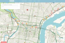
The more in-depth Technical Report (PDF) provides technical information and the methods of analysis used to determine the potential exposure of Caltrans District 4’s State Highway System. The report is supported by an extensive GIS database and Caltrans has developed an interactive mapping application for public use, which shows impacted locations and the climate model results, the agency says.
Both reports and the interactive mapping application, as well as more information, can be accessed on Caltrans’ Office of Smart Mobility and Climate Change Vulnerability Assessment page.
Using the data from the study, Caltrans says it intends to help evaluate the vulnerability of other modes of the transportation system through partnerships and data sharing with local and regional agencies.
“As Caltrans moves towards a resilient transportation system, the department will continue to enhance its climate effort and close partnerships with local, regional, state and federal agencies in order to create coordinated adaptation solutions for the state transportation system,” a press release says.
 Storm damage to a California highway, before the Santa Barbara mudslides. Photo courtesy of California DOT.