Roadbotics image.
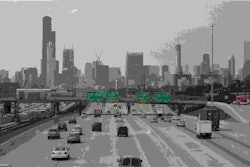
Roadbotics has developed intelligent systems to improve and speed up data collection on road conditions, which can help cities and municipalities make capital spending decisions more efficiently, Engineering News-Record reports. The company, which was founded in 2016, is based on machine vision technology developed at Carnegie Mellon University that collects footage from windshield-mounted cameras driving the roads.
The technology’s computer vision algorithm has been trained to recognize flaws in road surfaces, including cracks, potholes and spalling, and geotags the locations, rating them on severity. That data is collected into a map file that can be loaded into GIS imaging software.
“Normally this is a time-consuming and costly process,” said Ben Schmidt, Roadbotics CTO, according to the news agency. “Here, we snap our fingers, and there’s a comprehensive view of your road network.”
One of Roadbotics’ first customers was Ryan Fonzi, associate planning director for North Huntingdon Township, Pennsylvania, who needed a faster way to track the 160 miles of road under his supervision. “Their data was important for us — we can pull up conditions in certain wards,” Fonzi tells ENR. “We have an unbalanced situation here where some wards are in better or worse shape, but now we can look at it township-wide. We have the data to help us make smarter decisions.”
Prior to using Roadbotics, the process took four to five months every few years. With Roadbotics, an intern was able to drive the township’s roads with a camera mounted on the windshield in just a week or two. Processing the data took a few more weeks.
“The real benefit to us is the Shapefile that Roadbotics delivers,” Fonzi told the news agency. “With that we can load it directly into our GIS and start making planning decisions right away.”
Feedback from customers has helped the product evolve. “Our first product version just showed point data,” Schmidt told the news agency. “So we did a version of the software that calculates ratings for entire road segments and overlays it over the map as an option.”


Having video and still images of road conditions available is useful in haggling with public officials over funding for roadwork, says Michael Turley, assistant township manager for North Huntingdon, according to the news agency. “When dealing with a governing body we can show something that isn’t just a matter of a human opinion,” he explains. “Before, it was us going out and saying to them what the condition was, but this is just what the camera sees. We can pull this up at public meetings and settle debates there.”
Roadbotics has been been looking at ways to improve its technology since the first trials began almost two years ago. It is currently working to schedule scans of road networks every one or two years to create a visual timeline to aid long-term capital planning.
“We’re looking at things that can radically change how pavement is monitored and maintained going forward,” says Schmidt, according to the news source. “Our customers are already seeing how this could change the way things are done systemically in the future.”