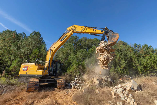
Moving dirt 100 percent accurately the first time seldom happens with excavation projects. Tradition calls for surveying and project design, estimating and laying out stakes and finally excavating and finish grading the site. Contractors often have to go back in and redo grade work, which takes money and time. Although digging for a living has proven profitable in the past, technology has emerged in recent years to make it easier, more efficient and, most importantly, safer.
“Contractors are required to move dirt correctly the first time,” says David Pinaire, marketing/customer service manager for Caterpillar’s productivity solutions division. “But usually, they only move it correctly 80 percent of the time – leaving error 20 percent of the time.”
Project mistakes aside, the National Institute for Occupational Safety and Health reports an average of 1,000 trench collapse injuries and 50 to 100 trench-related fatalities per year. Removing laborers from the trenches could bring a reduction in trench-related incidents occurring regularly in the earthmoving industry.
Global Positioning System technology for excavators eliminates guesswork and errors, while getting workers out of harm’s way. “Excavators are normally used to move large amounts of dirt, but as technology improves excavators are transforming into more of a finish grade machine, rather than just a mass earthmover,” says Matt Scothorn, machine control sales manager for Leica Geosystems. “Meanwhile, the safety aspect of GPS allows operators to check grades on their own.”
Laying it on the line
For the past six years, GPS systems have been used as a fine finishing tool, primarily on dozers and graders. In the last year, GPS manufacturers added excavator systems to their product lineups.
The initial layout process for excavator GPS systems still begins with a set of plans, but in a much less time-consuming manner. A project engineer sends a 2-D or 3-D digital file of the plans to the contractor, who then transfers the information from a computer or software program to the excavator’s in-cab GPS monitor. Surveying and grade checking become unnecessary, as a base station and rover localize points to achieve plus or minus a tenth of a foot of original measurements.


The system measures topography and guides the machine in real time using signals from a series of satellites, GPS receivers mounted on the machine, sensors mounted on the bucket, stick, boom and chassis and digitally transmitted data.
Most GPS units have plug-and-play capability – meaning you mount the monitor, sensors and receiver, connect them and adjust as necessary – so components can be added or removed at any time. The only other requirement for GPS-guided excavating is a surveyed control stake at the site to serve as a starting point and to help measure the finished grade, Scothorn says. “Instead of complete grade staking, contractors save money on potentially thousands of stakes by using control staking,” he says.
Less time spent waiting on survey crews and grade checkers enables contractors to reap the productivity rewards. “Personnel and machine costs are reduced,” says Arthur Taylor, segment manager for Trimble’s 3-D Machine Control division. “Material usage, fuel costs and site delays can be minimized.”
Seeing is believing
The GPS systems used on dozers and motor graders can be configured as indicate only (meaning the operator controls the blade position by watching the computer screen in the cab) or as automated machine control systems. In the automated systems, the GPS ties into the machine’s hydraulics and raises or lowers the blade automatically.
Currently, GPS excavation systems come in indicate mode only. The cab monitor displays the bucket position and elevation, using arrows or lights to direct an operator’s adjustments and positioning.
“At one point, Topcon offered an automated excavator system, but it didn’t catch on because good operators were quicker to grade slopes by using the indicate system alone,” says Rodney Thomas, Topcon dealer and sales representative for Benchmark Tool and Supply in North Carolina.
Getting it right the first time
New GPS units often achieve results within a half inch or less on grading jobs and some contractors say they’ve experienced accuracies of within 5 and 10 hundredths of a foot. “Two GPS antennas and the GPS sensors determine machine position and by combining the angle sensors for bucket position, the operator knows where the bucket cutting edge is in relation to the machine on the job,” Scothorn explains. Thus, GPS not only eliminates the need for paper plans, surveyors, staking and grade checkers, it also far outranks previous methods in terms of exactness.
Two aspects determine a cut’s accuracy: the GPS system itself and the 2-D or 3-D data compared to the data measured by the angle sensors on the cab, boom, stick and bucket.
“Since you’re sitting up high (in the cab) your judgment of levelness can easily be thrown,” says Shane Thompson, president of Thompson Grading in Woodruff, South Carolina. “With GPS, you can see bucket elevation and hit your mark without having someone check the distance or depth every 20 feet. With the old style, you had to check religiously and possibly redo your grade work – now it’s much more efficient.”
Thompson recently bought a Topcon GX-60 for his Komatsu PC-600 and has had GPS on most of his excavator fleet for eight months. He also has Topcon units on his bulldozers and other equipment, and plans to purchase a few additional units for his excavators.
“In the beginning, the price may turn people off,” Thompson says, as it did him at first. On average, excavator GPS units cost $55,000 to $60,000 and around $40,000 for the base station and rover. “But after you’ve done two or three jobs, you really see it helping your return on investment,” he says.
Risk reduction
Luckily, safety and accuracy improvements come hand in hand with excavator GPS units. The manual staking method put workers directly in the path of machinery, which slowed progress and increased the danger of workers getting buried alive.
“GPS allows the operator to dig independently without having another person checking grades in the trench, thereby increasing safety,” Scothorn says.
With GPS, Thompson says he no longer worries about possibly harming someone working on the ground, which allows him to run the machine at a comfortable pace.
No more trench boxes, shoring or shielding? Thompson says not only does he appreciate GPS’s safety factor, but his workers do, too.
In turn, reducing the number of injuries and deaths lessens chances of having to pay for the costs of accidents, such as work stoppage, attempted rescue, and replacing workers and NIOSH claims.
Bridging the gap
As with any type of new technology, GPS’s learning curve may scatter users broadly from one end of the spectrum to the other.
Hands-on training usually proves helpful for new GPS users rather than just skimming the user’s guide. Benchmark Tool and Supply includes a training fee in the total GPS cost. “A representative trains the construction company’s superintendent or whoever has been designated to oversee the GPS fleet for about an hour on the Topcon GX-60,” Thomas says. “We will return at a later date to do follow up training once the operator has gotten a basic feel for the system. This seems to work best for the contractor.” Thomas says Benchmark typically asks the owner to select a dependable employee that can be trained along with the operators. That way, if an operator leaves, another can be shown basic instructions and keep the machines from having unnecessary downtime.
Trimble dealers also provide on-site, in-the-cab training of machine operators who’ve recently purchased an excavator GPS system, Taylor says, to ensure a base level of comfort and confidence. Depending on the type of installation, machine type and usage scenarios, training generally lasts about one to two days.
Even contractors who don’t normally go for technology can value GPS, says Thompson, who was trained by Thomas after purchasing his GPS unit from Benchmark. As he points out, plug-and-play GPS doesn’t require much thought. “You just hook it up and the picture loads right away,” Thompson explains. “My operators loved it after three or four days on the job, comparing it to a video game. They don’t have to worry about cutting or filling too much – they’ve instantly got grade.”
Within a week, not one of his operators wanted to give up GPS and return to previous methods.
“Human nature is to fear change,” Scothorn says. “Some contractors have difficulty facing it and resist new technology, but to remain competitive and survive in the industry, it’s best for them to be educated.”
GPS Solutions for your jobsite
Take a look at some of the GPS systems available now.
Caterpillar AccuGrade GPS system for hydraulic excavators
- Compatible with Caterpillar’s 320D, 324D, 325D, 330D, 345C, 365C and 385C
- Uses machine-mounted components, an off-board base station and Real Time Kinematic (RTK) positioning to determine bucket positioning
- Indicate only, in-cab 3-D display equipped with light bars allows users to view bucket elevation, how much bucket tip is needed for appropriate depth, bucket’s position in relation to the design surface and a graphical view of the design plan with machine location
- Uses a Controller Area Network (CAN) designed for plug-and-play capability
- MS990C GPS receivers for tracking capabilities, includes technology for faster RTK initialization times
Leica Geosystems DigSmart 3-D Excavator Guidance System
- Uses an electronic design file of the site to guide digging
- Graphic color monitor displays project design information and 3-D GPS position, allowing operator to set proper bucket elevation and position
- Dual GPS antenna system indicates bucket teeth position anywhere on site
- Indicate only mode
- Integrates with Leica’s Roadrunner software, System 1200 data for coordinate transformations and GPS 1200 sensor modules
Topcon 3DXi for excavators
- Consists of two GPS antennae, a GPS receiver and the GX-60 control box
- Combine up to three user-defined views including plan, profile, sectional and single or dual grade indication
- Four temperature-compensated, 360-degree, CAN-based tilt sensors measure angles
- GX-60 color, touch screen control box aids as a steering indicator, as well as displaying machine position
Trimble GCS900 Grade Control System
- Dual antenna configuration for installation on excavators with standard buckets or tilt buckets
- Using system on excavators with tilt buckets allows for shaping V-ditches and digging slopes not perpendicular to the boom
- Trimble AS300 Angle Sensors have no moving parts and can be submerged in up to 66 feet of water for underwater applications
- On-board Trimble CB430 Control Box determines blade or bucket position and compares to design elevation
- In-cab, mounted light bars show what bucket movement is required to get grade