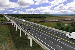
The first section of the new Interstate 11 between Nevada and Arizona is being built in two phases simultaneously.
A new two-mile section of an interstate highway that will eventually link Las Vegas and Phoenix – and one day, Mexico and Canada – is causing some confusion for drivers relying on GPS systems, the Las Vegas Sun reports.
 The new Interstate 11 shield signs are expected to be installed this year.
To help remedy the problem, the Nevada Department of Transportation plans to change interstate shield signs to Interstate 11 instead of U.S. 95/Interstate 515 by the end of the year. I-11 is not recognized by most GPS programs. But one day, it will be recognized by millions as it provides a north-south link across the United States.
So far, though, the project is just in the beginning of its first phase – to become a 15-mile freeway around the southern perimeter of Boulder City from I-515 to U.S. 93. The first phase is being built in two sections simultaneously, with the NDOT managing a 3.5-mile segment and the Regional Transportation Commission of Southern Nevada managing the remaining 12 miles.
The NDOT says the 15-mile interstate will alleviate congestion between Arizona and Nevada, as well as improve safety and increase travel and commerce between the two states. It is scheduled to be completed next year.