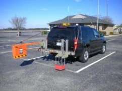
The project incorporated both vehicle and walking-based surveys using Ground Penetrating Radar (GPR). As a result, no cores or test pits were used to obtain utility location information.
A majority of the survey utilized a vehicle-based system, operated at close to driving speed, to minimize disruption to traffic flow. The information obtained will facilitate planning efforts associated with the safe installation of a fiber-optics utility line. It is important for the project planners to understand the in-situ conditions, including the pavement thickness and utility locations, to plan a proper rehabilitation of the roadway and mitigate the risk of damaging existing utilities.
The field work was carried out by Infrasense on the three-mile section of roadway in just one night. Despite the thickly settled location of this section of road, which carries relatively high traffic volume between Bristol and Warren, the surveys were performed without causing any traffic disruptions or backups. In order to detect all utilities and assess the pavement structure, Infrasense engineers used both walking and vehicle-based surveys. To detect utilities that are buried transversely across the road width, data was collected along the length of the road using the vehicle-based system. To detect utilities buried longitudinally along the length of the road, data was collected across the width of the road with the walking survey system.
Ground penetrating radar is a nondestructive evaluation technique that operates by transmitting short pulses of electromagnetic energy into the concrete or asphalt pavements, using a boxed antenna attached to a survey vehicle or rolled along the pavement. These pulses are reflected back to the antenna providing a record of the properties and thicknesses of the layers within the pavement. GPR can detect the depth and spacing of utility lines or other metallic objects, as well as the thickness and reinforcing steel of concrete slabs.
It is also able to detect subsurface deterioration of a slab through changes in the radar signal through the concrete. The variety of GPR configurations and settings allows for adaptation to the unique constraints of many different utility projects.


