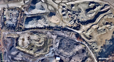
 A Nearmap aerial view of a construction site in Stoughton, Massachusetts. Photo credit: Nearmap
As many construction firms go to drone technology for site mapping, Australian-based company Nearmap is offering an advanced, digital take on a more traditional form of aerial photography: airplane flyovers.
The Australian-based company flies over 72 percent of the U.S. population up to three times a year with plane-mounted cameras. It offers high-resolution aerial views, including 3D views, of metropolitan areas for various industries, including construction and paving contractors.
Nearmap also provides tools that can digitally measure area, radius and even building width and height on its 3D aerial views. And unlike deploying a drone, the service doesn’t require you to leave the office.
During the 2019 World of Asphalt show in Indianapolis in February, Nearmap global director of customer engagement Mike St. Louis discussed the services his company provides. He used as an example a hypothetical project to repave the parking lot of Lucas Oil Stadium, home to the Indianapolis Colts.
To prepare a bid for the project, the contractor can pull up the image of the parking lot with the Nearmap service. This can be done by searching the address or typing in the stadium’s name.
The view is similar to what you would see on Google Earth; however, the high-resolution Nearmap image is much clearer.
“Our imagery is four times clearer than free satellite imagery,” St. Louis says. The maps provide a 3-inch or less ground sampling distance, for 3 inches per pixel.
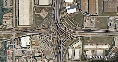 A Nearmap aerial view of the I-30/U.S. 75 interchange in Dallas.
The measurements for the parking lot can be taken from the office, meaning no need to send workers to walk the site, he says. Nearmap can be used to determine preliminary quotes on materials needed, any elevations to be concerned with and how long the project would take.
During the design phase, Nearmap tools allow contractors to color code areas, such as designated handicapped spots or trailer parking. Trees can be marked that need to be cut, and their radiuses measured. The system allows text annotations to be added to the map to give instructions, such as where to dump materials.
The map can then be exported digitally to the project team, emailed or printed out. It can also be integrated into other systems like CAD or ArcGIS. When using other mapping systems, the Nearmap view serves as the base layer, which can be overlaid to show roads, streets and other features.
Nearmap runs thousands of flights a year with contracted pilots. During the flyovers, “the camera just spins and captures all the imagery and then uploads into our map browser,” St. Louis says.
The planes are equipped with Nearmap’s proprietary two-part camera system. The system consists of HyperCamera 1, which provides the vertical view, similar to Google Earth; and HyperCamera 2, which captures a 45-degree angle view that allows for such things as measuring the sides and heights of structures. Its screen view looks similar to a video game.
All of the photos are meshed together to form a mosaic. St. Louis says the maps are geospatially correct. As an example, he said, you could measure from goal line to goal line at Lucas Stadium and there would be 6 inches or less in difference.
St. Louis says the system is not designed to replace site visits or customer interaction.
“We’re just trying to make it easier for them to have the information upfront to begin with, to get that foot in the door even quicker,” he says. Along with preparing for bidding, a company could use it for marketing to show before and after photos of work it has done, and for prospective clients by presenting them with photos of areas that need improvement.
St. Louis says Nearmap also provides advantages over drones.
“A drone, you’re going to capture an area and that’s very specific to that area,” he says.
Nearmap will give a broader view. For example, if you have a larger paving project, “you will be able to go from one intersection to another intersection as opposed to bits and pieces.”
St. Louis says most of Nearmap’s customers use the service as their primary map source, but some also use it as a secondary source, “when they want to see more area or can’t get a drone up in time.”
St. Louis adds, “When we capture the imagery it takes a matter of days to get it into our cloud system, our map browser.”
Currently, the 3D views are not available on the cloud-based views but are provided by the company on thumb drives to customers. Plans are to add 3D views to the cloud-based maps, St. Louis says.
The company conducts its schedule of flights in spring and fall when tree canopies won’t block ground views, they also fly during leaf-on times. The service also provides historical views, so contractors can see previous work done and when.
Nearmap charges monthly or annual subscriptions. With that, customers have access to all its U.S. map views and its tool set. Pricing is based on usage and can be adjusted depending on how often the customer needs to use the system.
Nearmap continuously looks to expand its coverage, St. Louis says. It plans to conduct flyovers in Canada within a year, and it often hears from U.S. customers about areas they would like Nearmap to cover.
To see how the 3D measuring tool works, watch the video below:

