One of the biggest reasons drones and unmanned aerial vehicles (UAV) went from a hobbyist gadget to an industry expected to generate 100,000 jobs and $82 billion for the U.S. economy over the next 10 years, is their low barrier to entry.
With as little as $100 you can grab a UAV from Amazon and start taking aerial photography from your backyard. And if you’re impressed and want to start piloting one around your business or jobsite, an aircraft with HD cameras and decent battery life can be had for under $1,000.
But beyond the initial rush of excitement generated by excellent aerial imagery for such a low one-time cost, many business owners quickly discover the intricacies integrating a drone workflow into their business can entail. Though the Federal Aviation Administration’s commercial drone regulations turned out to be extremely reasonable, most business owners will still need to pay someone to operate and maintain their drone fleet. (To get an idea on how complex that can be, check out our feature on Rogers-O’Brien.) And if you’re using the images obtained by these aircraft for surveying, you’ll need to figure out which software best fits your needs in taking the images obtained by your drones and turning them into usable maps.
Last year we heard from a company called DroneBase that takes a lot of worry off of the plates of construction professionals through a rental service. But now, drone maker Kespry has released what might be an even easier way for construction companies to use drones on the jobsite.
The company offers what it calls an “aerial intelligence platform” that fully integrates the drone hardware and image rendering software in order to provide a drone that not only flies itself, but delivers ready-to-use imagery with almost no operator intervention required.
Hardware upgrades
In an interview with Equipment World, Paul Doersch, the founder and CEO of Kespry, says that the construction and mining industries have been a primary focus for his company since its founding in 2013.


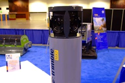
The new quad-rotor hardware, dubbed Kespry Drone 2.0, boasts several key improvements based on feedback the company received from its customers. At 22 inches from rotor to rotor and weighing in around 4 pounds, this new drone is lighter than its predecessor, flies twice as long at 30 minutes per flight and covers twice the ground area at up to 150 acres at an altitude of 400 feet.
Maybe most impressively Kespry Drone 2.0 is twice as wind resistant as its predecessor, able to fly effectively in wind speeds up to 25 miles per hour while withstanding gusts up to 35 mph. “It’s a combination of how the air frame is designed, the flight system and the size of the rotors: the speed and how they turn,” Doersch says.
 Telling Kespry’s Drone 2.0 what to map is as easy as drawing a circle through its iPad app.
How it works
As great as the hardware is, it’s all largely in service to the software, which is the backbone of the user experience Kespry has placed at the forefront of its platform.

Here’s how the entire process of setting up the Kespry Drone 2.0 works:
• Kespry ships a drone upon sign-up.
• A couple of days later the drone arrives.
• After opening up the package, you call Kespry and speak to a customer service representative for about an hour as part of the initial setup process.
• When you’re ready to start mapping, you open the Kespry iPad app, draw an outline around the site you want mapped on the screen, drag a slider to the height you want the imagery taken from and launch the drone.
That’s it. From there, the drone takes off, maps the site and lands in the exact spot it took off from. During flight, an on-board LiDAR sensor automatically detects and avoids obstacles like trees, cranes, and buildings.
Upon landing, the drone then connects to WiFi and uploads the images to Kespry’s cloud-based backend. In the cloud, Kespry’s software handles the work of organizing all the data and converting the images into a 3D model. This can take as little as 30 minutes or up to three hours depending on the amount of data collected.
In order to ensure a high quality image, Kespry has outfitted the Drone 2.0 with the lightweight Sony UMC-R10C industrial camera the company says “captures more geospatial data for detailed 3D models that assist companies in areas like mine planning, operations, inspection and safety.”
And once everything is ready, all the images and data can be browsed at cloud.kespry.com.
You might be wondering, “What if my site is larger than 150 acres?” Doersch says if the site is too large, the drone will land, allow you to pop in another battery, take off again and continue mapping.
Pricing
And because this experience is vastly different than what the majority of drone hardware manufacturers are offering, the pricing is different as well. Rather than selling the hardware outright, or selling the hardware at a certain price point with an optional subscription to the cloud service, Kespry is treating the entire platform as a yearly equipment lease.
The Drone 2.0 and Kespry Cloud service are priced between $30,000 and $40,000 per year, depending on configuration, and Doersch says the company supplies everything its customers will need.
Doersch says the majority of Kespry’s customers are larger firms already using drone imagery on a regular basis. Packaging the hardware and software as a yearly lease was in part necessary because the two are so tightly integrated at the engineering phase that you can’t really have one without the other.
And though drones are quickly becoming another piece of equipment contractors are budgeting for, Kespry is selling a comprehensive service, not just a tool.