Learning new technology presents challenges. When that technology combines big iron earthmoving with in-cab computers and radio signals from the edge of space, the challenge is doubly difficult.
But once contractors get on top of the learning curve with GPS (global positioning system), their productivity soars. Still, learning how to use and take full advantage of GPS machine guidance and control systems requires more than a few hours of study. If you’re new to the subject you may need to invest several months to a year learning everything you can about it.
It’s not that the hardware is complex. The components are only a little more complicated than laser guidance systems. But to keep up with the productivity gain that GPS offers you have to build jobs differently, rethink who does what on the jobsite and reconfigure your business models. It won’t do you any good to have a GPS-enabled dozer or grader moving 50 percent faster if you have to park it for half a day while the crews or other machines play catch-up. That’s like having the world’s greatest quarterback and no linemen to protect him.
- Start by asking questions.
The manufacturers of GPS equipment and many of the larger heavy equipment dealers regularly host education sessions – everything from local demos to big national conferences. This is a good way to get a feeling for the hardware, but it’s just a beginning. If GPS were a book, this would be the first chapter.“The ones who are successful make themselves learn it,” says Rich Calvird, product-marketing manager for Leica Geosystems. “They’ll do short courses, seminars, online courses; they’ll find all the resources. But it’s more than just reading a manual. It takes some initiative.”
In addition to this basic research, Calvird says it’s essential to talk to people who are knowledgeable about GPS and construction. Small contractors who don’t have an in-house survey crew would do well by talking to engineering or surveying companies that do what’s called “data prep” on the CAD files, says Calvird. Data prep converts the engineer’s drawings (paper or CAD) into digital files that can be read by the machine’s computer. Calvird also recommends finding a non-competing contractor who has some GPS experience and talking to them.
- Decide to commit.
Murray Lodge, director of sales for construction at Topcon Positioning Systems, likewise recommends you take in the road shows and other manufacturer sponsored educational events. But the key to moving forward, Lodge says, is to make a company-wide decision that this is what you want to do.“If you just dabble in it, you won’t have the same success as a company that says, ‘OK, we’re going to adopt this technology and we’re really going to work to implement it in the company.'”
- Identify your support.
The next issue, says Lodge, is to identify the support structure for your region, including your local distributor, GPS-experienced equipment dealers and any of the survey or engineering companies you do business with. “You’re taking a big technology step,” he says. “I don’t care how smart you are or how smart the people are on your staff. If you want to shorten the learning curve you’re going to need assistance. The local support is a key factor in your success and in the amount of time it takes you to succeed. No one person can do it all.” - Try a rover.
While both Calvird and Lodge agree that there is no one-size-fits-all approach, they both think getting a GPS rover and base station can be a good way for many contractors to begin to get a feel for the technology without having to learn from the seat of a machine. A rover is a GPS receiver with a small computer screen mounted on a pole that you take around jobsites and check topos and elevations and compare them against what’s provided on the plans. Originally designed as surveyor’s tools, rovers are increasingly being designed with the needs of earthmoving contractors in mind.“A base and rover is a fantastic way to get started,” Lodge says. “It allows you to understand the whole principle of GPS: getting your model, putting control on a jobsite and tying that jobsite into the GPS satellites.”
The rover experience can help earthmoving contractors and supervisors better visualize the relationship between GPS machine control and the digital site plans, Calvird says. “A contractor with no GPS experience or staff engineering or surveying resources can be overwhelmed by jumping straight into GPS machine control,” Calvird says. “A rover helps them get a handle on the surveying and data side of things.”
- Target specific machines.
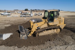
GPS machine control devices typically go on dozers, motor graders and more recently excavators. Some contractors use GPS to guide bulk earthmoving, others use it for finish work, and some for both types of work. While some choose indicate-only systems, others go for full machine automation (see What is GPS?, page 56, for definitions).As a general rule, contractors put indicate systems on dozers for bulk earthmoving and automated machine control systems on graders to precisely guide the blade on final finishing passes, Calvird says. But there are plenty of automated systems going on dozers too.
“It all comes down to what kind of work you do,” Lodge says. The key is to look at the work, analyze the processes and determine what kind of setup works best for the job. Keep in mind this may differ from job to job.
Many contractors also put the valves, brackets and cables for a GPS system on numerous machines. The expensive component – the in-cab computers – are then kept in a suitcase and moved from machine to machine as the job dictates, Lodge says.
- Rethink workflow.
It makes no sense to put GPS on one machine only to have it outpace everything else you’re doing on the site. Do that and all you gain is that you put fewer hours on the GPS-equipped machine.“You need to rethink how you build a job, Lodge says. “A significant number of those stakes are going away.”
In addition to rethinking how you build individual jobs, there’s a lot to be gained by rethinking the amount of work you plan for and your mix of jobs. If you do everything right and boost overall productivity say 30 percent, you’re going to have to line up 30 percent more work in the future or send crews home early.
A lot of small contractors use their GPS enabled productivity to compete with bigger firms, Lodge says. And earthmoving jobs that may have once been too complex for a small company without in-house engineering and survey support can now be done with GPS enabled machines and no additional people or resources.
- Choose a champion.
Getting training for everybody involved in the process is important in the beginning. But the companies that maximize their GPS return on investment also have a GPS champion. “This is your point man, a person who gets trained above and beyond everyone else,” Lodge says. “He’s the go-to person for anyone with questions or needing support.”Calvird adds that it has to be somebody who loves the technology and wants the job. And you have to give them the time and resources to learn. “You don’t want them saddled with so many other things that it becomes something they do in their spare time or at home after work,” he says.
In addition to continually upgrading his or her skills and knowledge, your GPS champion should also provide training to everyone else in the operation. “The more that everybody understands how it works – your grade checker, your foreman, superintendents and operators – the more effective you become,” Lodge says. If they know how the system relates to the control points, then everybody’s following the same playbook, he says.
What is GPS, and why do I need it?
GPS earthmoving systems work like the GPS navigation systems used in many cars today. The device in your machine/car is preloaded with a map and a receiver in the machine/car intercepts GPS signals from satellites in orbit that establish its position and then show that on a screen to the operator/driver.
With one exception. Automotive systems are accurate only to about 10 meters – good enough to find a restaurant, but too broad for cutting in a roadbed or leveling a building pad. To get the accuracy needed for construction, GPS earthmoving systems employ two receivers: one on the machine and one on a base station set up over a known survey point somewhere on the edge of a site. Since it’s on a fixed survey point, the base station already “knows” exactly where it is. So it communicates this to the machine via a radio signal and thanks to some high-powered software, the two receivers triangulate the exact position of the machine moving in real time down to about a tenth of a foot.
For contractors who want to do finished grade work with tolerances tighter than a tenth of a foot, manufacturers of GPS earthmoving systems use different types of technology to get you there. Because the systems differ, this is a subject of some complexity and beyond the scope of our discussion here. Suffice to say, if you know or even suspect that you might use a GPS system in the future for finish grade projects, you need to investigate this aspect of the technology thoroughly.
Within the GPS offerings there are two basic types of systems. Indicate systems show the operator where he is on the site and how much material needs to be moved relative to the plan. Automated systems tap a valve on the machine’s hydraulic block to move the blade automatically in response to inputs from the machine’s on-board computer. With automated systems, the operator benches the blade at the start of the job and then lets the system guide the blade from there.
What makes GPS valuable is primarily the reduction in the number of stakes that have to be put on a jobsite and the amount of grade checking that needs to be done during a job. Some preliminary staking is usually required, but after that, re-staking or resurveying is rare and the operator in the cab does his own grade checking by looking at the GPS computer screen.
Also on finished grade projects when using automated blade control, the quality of the end product is enhanced in that there are none of the washboarding or little imperfections that occur as an operator tries to eyeball a straight, flat path between 25-foot or 50-foot staking intervals. Automated control makes any operator more productive, but it can also make a medium-skilled grader operator as productive as the higher skilled operators.
