![]()
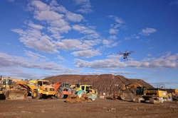
On most trips to John Deere’s Coal Valley, Illinois, demonstration site, Equipment World editors are focused on the ground, specifically the yellow machines moving the ground around.
But on my most recent trip to Coal Valley, I spent some of my time looking up instead, as Deere representatives demonstrated the company’s latest product category: drones.
In the run up to ConExpo earlier this year, Deere announced that it had struck an exclusive distribution deal with Kespry, a San Francisco-based startup building drones that not only fly themselves but upload the aerial data they capture to the cloud where it is transformed into 3D, survey-grade models. The drones are leased to companies on a yearly basis. Pricing is between $30,000 and $40,000 per year.
At Coal Valley, Deere WorkSight instructor B.J. Bauman took us through each step of a Kespry drone flight. Impressively, within 10 minutes, Bauman had programmed the drone and launched it. In as little as 30 minutes after the aircraft lands, the system is capable displaying the resulting survey map. You can see the process of launching the drone in our video of from the demonstration right here:
The demonstration started with Bauman opening up the Kespry app on an iPad. With your lease of a Kespry drone, you are provided with the drone itself, 5 gigabytes per month of wireless data connectivity and an iPad. Bauman says the iPad is included because Kespry has registered your drone to that iPad specifically for data security purposes. (The Kespry app installed on any other iPad than the one included with your drone, Bauman says, will not be able to communicate with the drone.)
With a few taps inside the app to specify the type of flight Bauman wanted the drone to perform, he then simply used a map view to crop a square around the area of the Coal Valley site he wanted the drone to survey.
And though the Kespry system flies your selected survey area all by itself through an automated flight system, you’ll still need a piloting certification from the Federal Aviation Administration in order to legally operate the drone. “You do have to be Part 107 certified,” Bauman says. “It’s about $150 to take the class.”


After walking outside, Bauman pointed out a GNSS base station that acts as a single control point. Unlike other drone surveying solutions that require placing multiple control points, this one control point is all that is needed to orient the Kespry drone and keep it flying in the correct location.
After performing what Bauman called the “drone dance” where you spin the drone in a circle as part of its calibration, the launch button was pressed inside the app and the drone took off for the selected survey site.
During the flight, the Kespry drone collected images and data from the base station simultaneously. Bauman talked a bit about the detail the drone’s camera is capable of capturing. “This camera is extremely powerful. You can see the grouse marks from machines on a flight from 100 feet,” he said. “We had another flight’s where the RAW images actually showed deer tracks.”
At the end of the flight, the drone turned back toward the launch site and quietly landed. Once back on the ground, the Drone connected to the internet using the 4G hotspot integrated into its carrying case. It uploaded the images it captured and the base station data to the cloud where Kespry’s software converted the images into a 3D model. The data conversion process can take as little as 30 minutes or up to a few hours, depending on the amount of data you’ve collected.
Bauman says the 3D data can be exported from the cloud in all of the major formats.
And that’s about it. If the process sounds incredibly simple, that’s because it is. And even if you manage to somehow screw up and wreck your drone, Kespry will replace it for you free of charge.
Kespry drones will be available for purchase at Deere dealerships around the world in the coming months.